Drone LiDAR Services
High-Precision 3D Mapping and Analysis for Construction, Surveying, and Infrastructure Inspection
Drone LiDAR: Precision Measurement from the Sky
Sensoar specialises in providing advanced drone LiDAR services that deliver high-precision 3D mapping and analysis for a variety of industries. Our state of the art LiDAR technology, combined with our expertise in drone operations, allows us to capture detailed spatial data quickly and efficiently.
What Is Drone LiDAR Technology?
LiDAR (Light Detection and Ranging) is a cutting-edge measurement technology that uses laser pulses to capture highly accurate, three-dimensional data of the earth’s surface and built environments. When mounted on drones, LiDAR sensors provide aerial mapping capabilities that go beyond traditional cameras or photogrammetry. The result is a precise digital twin of the landscape, complete with elevation, slope, and structural details. For industries that rely on accurate spatial information, drone LiDAR is transforming how surveys and inspections are conducted.
Unmatched Accuracy and Efficiency
One of the biggest advantages of drone LiDAR measurement is accuracy. LiDAR sensors can achieve centimeter level precision, even in challenging environments where GPS signals or visual imaging might struggle. By collecting millions of data points in minutes, drone LiDAR drastically reduces the time needed for ground surveys. This efficiency allows organizations to cut labor costs, reduce safety risks, and deliver faster project timelines—all while maintaining exceptional data quality.
Applications in Land Surveying and Mapping
Surveying professionals are turning to drone LiDAR to generate high-resolution digital terrain models (DTMs) and digital surface models (DSMs). Unlike traditional methods, drone LiDAR can penetrate vegetation, revealing ground surfaces hidden under dense canopy. This capability is invaluable for topographic surveys, floodplain modeling, and infrastructure planning. With drones equipped with LiDAR, surveyors can map large or inaccessible areas quickly, accurately, and with minimal disruption to the environment.
LiDAR for Construction and Infrastructure Projects
Construction companies use drone LiDAR measurement to streamline site preparation, progress monitoring, and quality assurance. By producing precise elevation models, project managers can calculate cut and fill volumes, assess drainage patterns, and detect potential issues before they escalate. Regular LiDAR scans also support accurate progress reports, helping stakeholders track milestones and ensure compliance with design specifications. From highways to high rise buildings, LiDAR data keeps projects on schedule and within budget.
Environmental and Forestry Management
Drone LiDAR is a game-changer for environmental monitoring and forest management. Because LiDAR can capture ground elevation beneath vegetation, it provides detailed information on forest canopy density, tree height, and biomass. Researchers and land managers use this data to monitor ecosystem health, plan sustainable logging, and study erosion or watershed dynamics. Accurate terrain mapping also supports habitat preservation and climate change research, giving decision-makers a powerful tool to protect natural resources.
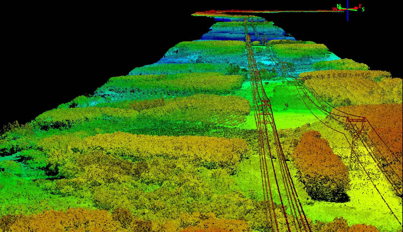
Utility and Power Line Inspection
Maintaining power lines, pipelines, and other critical infrastructure requires reliable measurement tools. Drone LiDAR enables operators to detect vegetation encroachment, identify sagging cables, and measure clearances with pinpoint accuracy. Unlike manual inspections, drone-based LiDAR reduces the need for dangerous climbs or helicopter flights, lowering operational risk and cost. Utility companies benefit from predictive maintenance, improved reliability, and regulatory compliance through accurate 3D LiDAR models.
The Future of Drone LiDAR Measurement
As LiDAR sensors become lighter and more cost-effective, their integration with drones will continue to expand. Advancements in real-time data processing and AI-powered analytics will further enhance the value of LiDAR data, turning raw point clouds into actionable insights. For businesses across surveying, construction, utilities, and environmental management, drone LiDAR represents not just a measurement tool, but a competitive edge.